Islands In Europe
13 of 67 listings · Clear Filter

€17,000,000EUR
Isola Grande
Sicily, Italy
Isola Lunga, also known as Isola Grande, is the largest of the four islands of the **Stagnone Lagoon Nature Reserve** on Sicily's western coast, opposite the city of Marsala. It is a long, low landmass running roughly ten kilometres north to south, forming the natural barrier that creates the shallow protected waters of the Stagnone. Without Isola Lunga, the lagoon and the salt pans that depend on it would not exist.
This listing covers approximately **88 of the island's 120 hectares**.
---
## What Is For Sale
The 88 hectares offered comprise the substantial majority of the island's land area, although not its entirety. Other portions of Isola Lunga are held under separate ownership or commercial concession, including the working salt pans on the western shore and the strict-protection sections of the nature reserve.
The land for sale includes:
- **Twenty bedrooms and twenty bathrooms** across the existing ruined structures, requiring full restoration
- **A dirt road** running through the maritime pine forest that covers much of the island's interior
- **A private dock** with direct sea access on the lagoon side
- **The "Tahiti" beach**, a fine white sand beach on the island's east side, one of the most distinctive coastal features of the property
- Several smaller secondary buildings in varying states of preservation, distributed across the southern reaches of the island
The Italian planning framework for this kind of property is the *recupero* (recovery) approach, which permits the restoration of existing structures to residential or hospitality use within protected nature reserve contexts where new construction would otherwise be prohibited. With twenty existing rooms across the ruined buildings, the restoration potential is substantial.
---
## The Setting
The Stagnone Lagoon is one of the most distinctive coastal landscapes in Italy. Sicily's largest lagoon, designated as a nature reserve in 1984, with four islands within it of which Isola Lunga is the largest. The shallow protected waters between Isola Lunga and the Sicilian mainland have supported salt production for centuries, and the lagoon today is recognised both as an ecologically significant Mediterranean wetland and as a culturally significant historic agricultural landscape.
The island itself carries the characteristic landscape of a long Mediterranean barrier island: maritime pine forest covering much of the interior, halophytic vegetation along the lagoon margins, low scrub on the higher ground, and Mediterranean herbs filling the air with the particular dry-summer perfume of western Sicily. The wildlife is the bird life of the lagoon, including the **pink flamingos** for which the Stagnone is well known, alongside herons, egrets, and the migratory species that use the lagoon as a Mediterranean rest stop.
The southern portion of the island operates as a strict nature reserve. The remaining acreage is the cultivable land where the existing buildings sit and where any restoration project would centre.
---
## The Salt Operation, As a Neighbour
The active salt operation on the western coast of Isola Lunga is the defining current activity on the island, and it is important for a prospective buyer to understand exactly what it is.
The salt pans are owned and operated by **Sei Saline**, a Sicilian company that has run the Ettore and Infersa salt works on the island and the adjacent mainland for decades. Since 2005, the company has also operated a **Salt Resort on Isola Lunga itself**: a small hospitality operation with rooms, a restaurant, and the historic restored windmills, marketed as part of their Sicilian salt-tourism experience. The Salt Resort takes bookings, hosts guests, and forms part of the existing island economy.
This is not a sleepy commercial concession in the background. It is a working hospitality and agricultural business already operating on Isola Lunga, with its own dedicated team, branding, and guest flow. The salt pans, the windmills, and the Salt Resort footprint are not part of this 88-hectare offering.
For a buyer evaluating Isola Lunga, this fact pattern matters in two ways:
**As an asset.** The presence of a refined, established salt-tourism operation already on the island provides a working model for what high-end experiential hospitality looks like in this setting, validates the buyer demand for it, and offers a potential strategic partnership for the right kind of new ownership.
**As a competitive consideration.** A new development on the 88 hectares that positioned itself as a salt-and-wellness destination would directly overlap with Sei Saline's existing operation. A new development positioned around different ground (a private estate, a wine-and-agricultural project, a marine-and-cultural retreat, a kitesurfing-oriented offering) would complement rather than compete.
A buyer should understand the existing operation in detail before deciding on a development direction.
---
## What Could Be Built Here
Three positions are credible for a thoughtful next owner of these 88 hectares.
**A private estate.** Restoration of the existing structures into a primary residence with guest accommodation, retaining the remaining acreage as private nature reserve. The dirt road, the private dock, and the Tahiti beach all support a serious estate-scale residence with the architectural and emotional advantages of a near-uninhabited 10-kilometre Sicilian barrier island as the setting.
**A boutique hospitality concept differentiated from Sei Saline.** The 20-bedroom existing footprint, restored, could carry a refined boutique operation positioned around themes the existing Salt Resort does not occupy. The east-side Tahiti beach lends itself to a beach-and-pine-forest positioning. The lagoon's reputation as a major European kitesurfing destination supports a watersports-oriented positioning. The proximity to Marsala wine country, to the Phoenician archaeology at Mothia, and to the Greek temples of Selinunte supports a cultural-tourism positioning.
**A marine-and-agricultural estate.** The Marsala wine region surrounds this property. A vineyard establishment on the appropriate parts of the island, paired with a restored estate residence, would create a Sicilian agricultural property of unusual character: vineyard, sea access, and the cultural and natural reserve context of the Stagnone.
Any combination of these is supportable across the 88 hectares.
---
## The Wider Region
Isola Lunga sits in one of the most layered cultural and natural landscapes in Italy.
**Marsala**, four kilometres east on the Sicilian mainland, is the cultural and commercial anchor of the region. The city is internationally known for **Marsala wine**, one of Italy's most famous fortified wines, with DOC protection and a long export tradition.
**Mothia (Motya)**, a small neighbouring island to the east, is one of the most important Phoenician archaeological sites in Italy, with a substantial museum and significant surviving ruins.
**The Stagnone lagoon itself** is one of the world's premier **kitesurfing destinations**, with shallow flat water, constant winds, and international competitions held in the surrounding waters annually.
**Selinunte**, an hour south, holds one of the finest preserved Greek archaeological sites in the Mediterranean.
**Erice**, a medieval Norman hilltop town above Trapani, is within day-trip range to the north.
**Palermo**, the Sicilian capital, is 90 minutes east by car, with its UNESCO-recognised Arab-Norman architecture, the markets, the restaurants, and the international airport.
---
## A Note on Italian Ownership
Italy is a member of the European Union, and **EU citizens** purchase Italian property on the same terms as Italian nationals. **Non-EU buyers** are welcome to acquire Italian property subject to bilateral reciprocity rules with the buyer's home country, which apply to nearly all major economies.
For properties within a designated nature reserve such as the Riserva Naturale Orientata Isole dello Stagnone di Marsala, the standard Italian planning controls apply alongside additional environmental restrictions. New construction is generally prohibited. The path to development is through the **recupero** (recovery) framework, which permits restoration of existing structures to residential and hospitality use. The 20-bedroom existing footprint of this property is what makes the restoration path viable.
The **Italian Golden Visa** programme is available to qualifying non-EU investors and provides a residency pathway that pairs naturally with significant Italian property acquisition. A licensed Italian property lawyer with specific experience in Sicilian rural and protected-area transactions should structure any acquisition.
---
## Access
- **From Palermo Falcone Borsellino Airport (PMO):** approximately 90 minutes by car, with direct international flights from London, Paris, Frankfurt, Madrid, Munich, Vienna, and most major European hubs
- **From Trapani-Birgi Airport (TPS):** approximately 15 minutes by car, with seasonal direct flights from London, Paris, Brussels, Frankfurt, Eindhoven, and other northern European cities
- **From Marsala to the boat dock at San Teodoro:** approximately 10 minutes by car
- **From San Teodoro to Isola Lunga:** approximately 15 minutes by boat across the shallow Stagnone lagoon, with direct landing at the island's private dock
- **By private yacht:** the lagoon's shallow depth limits direct yacht access; the deep-water port of Marsala accommodates yachts of significant size, with onward tender transfer
---
## The Position
Isola Lunga is the kind of property that essentially does not come to the open market: a substantial Sicilian island, in one of Italy's most protected coastal nature reserves, with twenty rooms of existing ruined structures available for restoration under the recupero framework, a fine white sand beach on the east coast, a private dock with direct sea access, and a maritime pine forest interior.
It comes with the working salt operation of Sei Saline as a neighbour, not as a partner or a competitor by default, but as a defining piece of the island's identity that the next owner will need to understand and work with.
For a buyer with the patience for a long restoration project, the cultural literacy to appreciate what they would be stewarding, and the means to honour a Sicilian landscape that has supported human activity for centuries, Isola Lunga is a position that few properties anywhere in the Mediterranean can match.
217 AcresFreehold Island Parcel
Listed 76 days ago

$1,000,000USD
Lake Mälaren Private Island
Stockholm County, Drottningholm, Sweden
The Swedish Royal Family lives at **Drottningholm Palace**, on the island of Lovön in Lake Mälaren, 11 kilometres west of central Stockholm. The palace, the gardens, the 18th-century theatre, and the surrounding cultural landscape were inscribed by UNESCO as a **World Heritage Site in 1991**, the first Swedish site to receive that designation.
This listing covers a small private island in the same waters of Lake Mälaren, within sight of the palace and within the same geographic setting. The island carries a 58-square-metre holiday home, a guest cottage, a gazebo, docking platforms, and a small neighbouring island included in the sale.
It is one of the rare private islands anywhere in Europe where the cultural setting matters more than the acreage.
---
## The Position
The view from this island, on a clear day, includes the **Drottningholm Palace complex**, the official residence of King Carl XVI Gustaf and Queen Silvia of Sweden since 1981. The palace itself was commissioned in 1662 by Queen Hedvig Eleonora and designed by Nicodemus Tessin the Elder and his son Tessin the Younger, both of whom drew on the French royal architectural tradition of Versailles to create what has been called the Versailles of Sweden.
Beyond the palace, the wider Drottningholm cultural landscape includes:
- **The Drottningholm Palace Park**, modelled in the formal French and English landscape traditions of the 17th and 18th centuries
- **The Chinese Pavilion**, an 18th-century summer palace within the gardens, one of the most refined examples of the European chinoiserie aesthetic
- **The Drottningholm Palace Theatre**, an 18th-century court theatre with its original wooden stage machinery still operational, used for opera performances during the summer season
- **The UNESCO-inscribed cultural landscape** as a whole, which includes Lovön and the surrounding waterways
The relationship between the island and the palace is not symbolic. From the property's shoreline, the cultural ensemble is part of the daily view across the water.
---
## The Property
The island itself is intimate by design and complete by function. A buyer is acquiring:
- **A 58 m² holiday home**, the main residence on the island, configured for the contained living that a small private island makes possible
- **A guest cottage**, providing separate accommodation for visitors or family members
- **A gazebo**, the outdoor social space for the long Swedish summer evenings and the morning sun across the lake
- **Docking platforms**, providing direct boat access for arrivals, departures, and the daily rhythm of an island life on Lake Mälaren
- **A small neighbouring island**, included in the purchase, expanding the privacy buffer and the recreational footprint of the property
The 58 square metres of the principal residence is purposeful. Swedish summer-house architecture at this scale tends toward the well-considered: every square metre worked into a multi-functional life. The buyer of this property is not acquiring a sprawling estate; they are acquiring a beautifully positioned, perfectly sized retreat, with the additional asset of a separate small island held under the same title.
---
## Lake Mälaren
**Lake Mälaren** is Sweden's third-largest lake, covering 1,140 square kilometres and connecting Stockholm to the wider Swedish interior. The lake holds **over 1,000 islands**, many private, some inhabited, some preserved as nature reserves, others working farms and country estates. The Stockholm archipelago, with which Mälaren is connected via the city's central waterways, has been considered one of the world's premier sailing and small-boat regions for over a century.
The water of Lake Mälaren is fresh, warm enough in summer to reach 26°C, and clean enough to support strong populations of pike, perch, zander, and the freshwater fish that have anchored Swedish lakeside life for generations.
The boat journey from central Stockholm to Drottningholm, taken historically and still today on the working steamship **S/S Drottningholm** or the motor vessel **M/S Prins Carl Philip**, is one of the most distinctive arrivals in Stockholm. The same vessels pass within view of this island on their daily summer routes.
---
## The Access
The island sits **800 metres from the mainland shore**, accessible by private boat. The mainland approach is supported by community-shared parking and boat-mooring facilities, with the queue system that governs many Swedish island communities organising the slot allocation. These spots are part of the property's community-facility rights.
- **From central Stockholm:** approximately 30 to 40 minutes by car to the mainland boat dock, or a longer scenic journey by water through Lake Mälaren
- **From Stockholm-Bromma Airport (BMA):** approximately 6 kilometres southwest, with direct flights from European hubs
- **From Stockholm-Arlanda Airport (ARN):** approximately 50 km, with global connections including direct flights from New York, London, Frankfurt, Dubai, and most major European capitals
- **From Ekerö:** approximately 4 kilometres, with the nearest village amenities
The combination of direct city access (within the metropolitan boundary of Stockholm), proximity to two international airports (one of them 6 km away), and complete island privacy is rare anywhere in Europe and almost unique within the orbit of a national capital.
---
## What This Property Is For
The island is too small for a hotel, too small for a multi-villa compound, too small for a serious commercial operation. It is exactly the right size for what it is intended to be: **a private summer home with one of the most extraordinary cultural views in Europe**, accessible to a buyer who does not need to be a billionaire to acquire it.
For a buyer who has been thinking about owning a Swedish island but has found that most properties in the Stockholm orbit are either expensive country estates or remote archipelago summer houses without the cultural setting, this is the genuine alternative. A 58-square-metre holiday home, a guest cottage, a gazebo, docking platforms, and a second small island. All freehold. All within view of the home of the Swedish royal family.
---
## A Note on Swedish Ownership
Sweden is a member of the European Union, and **EU citizens** purchase Swedish property on the same terms as Swedish nationals. **Non-EU buyers** are welcome to acquire Swedish property under the country's open foreign ownership framework, with the standard transfer process handled through a Swedish notary and the local cadastre office.
Sweden's property law is among the most transparent in Europe. The land registry is digital, comprehensive, and publicly accessible. Title is unambiguous. The transaction process is fast by European standards.
Swedish residency does not flow automatically from property purchase, but a property in this position pairs naturally with the kind of seasonal or part-year residence that a non-Swedish buyer is likely to operate. A licensed Swedish property lawyer should structure any transaction.
---
## The Position
The island near Drottningholm is an unusual category of property: small enough to be accessible at a price point well below the trophy-island tier, with a cultural and geographic setting that the trophy-island tier itself struggles to match. The Swedish royal residence is on the next island. The UNESCO World Heritage Site is the daily view. Central Stockholm is a 30-minute drive or a scenic boat journey. Bromma Airport is 6 kilometres away.
For the buyer thinking about a Stockholm summer home that they can actually own as a private island rather than as a lakeside cottage, this is the position from which to do it. Most of Sweden's private islands sit hours from the cities and offer wilderness rather than cultural setting. This one is the inverse: in the city, on the lake, with the royal palace as the daily horizon.
0.3 AcresFreehold
Listed 76 days ago

€1,100,000EUR
Middle Calf Island
Roaringwater Bay, West Cork, Ireland
The school on Middle Calf Island was built in **1835**. It served the children of the six families who lived on the island and also took pupils from the neighbouring islands of West Calf, East Calf, and Cape Clear, who arrived by boat each morning. The population of Middle Calf in **1841**, the year before the Great Famine began, was thirty-nine.
The school closed eventually. The families left, one by one. **The last family departed in 1937**, after which the island has remained uninhabited.
Today, Middle Calf is a 64-acre uninhabited private island in the middle of Roaringwater Bay, off the coast of West Cork. The ruined walls of four dwellings, the outbuildings, the field divisions, and the school's stone foundations are still on the land. A herd of approximately twenty-five **Kerry Bog Ponies** grazes the island year-round, the only continuous inhabitants left.
---
## The Land
Sixty-four acres of West Cork coastal grassland, with the characteristic profile of a Roaringwater Bay island: rocky ocean margins, sheltered green interior, the stone walls of generations of small holdings dividing the land into fields that the ponies now graze across.
The shoreline carries **several beaches**, with the soft sand that the Atlantic edge of Ireland produces in its quieter coves. **Several small freshwater lakes** are dotted across the interior, supporting the year-round water supply for the ponies and the seabird populations that nest along the cliffs.
The buildings on the island are ruins, in varying states of preservation:
- **Four ruined dwellings**, the homes of the six families documented on the island in 1841 and through the late 19th century
- **Outbuildings** associated with the agricultural use, in similar condition
- **Stone walls** dividing the historic fields, mostly intact, marking the centuries-old subdivisions of the land
- **The remains of the 1835 school building**, with its specific historical significance to the wider Roaringwater Bay community
The island does not have a pier. Boats land at the beach, in the traditional manner.
---
## The Kerry Bog Ponies
The current population of the island is a herd of approximately **twenty-five Kerry Bog Ponies**, an endangered native Irish breed historically used to carry peat from Irish bogs back to the homesteads that burned it for fuel. The ponies are well-suited to the island's terrain: their small hooves cause minimal damage to grazed land, they thrive on the low-protein Atlantic grasses, and they survive Irish winters outdoors without supplementary shelter.
The herd's role on Middle Calf is dual. It maintains the grazed character of the land that the families' sheep and cattle once kept open. And it preserves a meaningful working population of a heritage breed that exists, globally, in very small numbers.
The herd is included with the property in the transaction, which is unusual in the private island market and reflects the operating ecological condition of the island.
In **2022**, a documented expedition led by Jeremy Irons and the Crowley family relocated six ponies from this herd to Mannin Island for breed-management purposes, a public moment that placed Middle Calf briefly into the wider Irish conservation conversation. The herd has remained a defining feature of the island's contemporary character.
---
## A Note in History
Roaringwater Bay was, in the 19th century, a site of one of the most significant tenant-rights political struggles in Irish history. The **Land War** of the 1880s and 1890s pitted Irish tenant farmers against absentee landlords across the country, and the islands of Roaringwater Bay were at the local centre of that struggle.
In September **1890**, **William O'Brien MP**, the founder of the National League and one of the most consequential figures in the Irish nationalist movement, held a political meeting on Middle Calf Island in support of tenants who had been evicted from the neighbouring Castle Island. The meeting was part of the broader campaign that eventually produced the Land Purchase Acts of the 1890s and 1900s, the legislation that transferred ownership of Irish land from landlords to tenants and laid the economic groundwork for Irish independence in the 20th century.
The visible heritage of Middle Calf, the school, the dwellings, the stone walls, sits at the centre of one of the most consequential periods in modern Irish political and social history.
---
## The Setting
**Roaringwater Bay** is part of **Carbery's Hundred Isles**, the West Cork archipelago of more than 100 small islands that has been one of the most distinctive coastal landscapes of southern Ireland for centuries. The bay opens to the Atlantic, with the protected interior waters running between Cape Clear (the southernmost inhabited point of Ireland), Sherkin Island, Heir Island, Castle Island, Horse Island, the Calves, and the Skeam islands.
The wider region is one of the most active private island markets in Europe. Recent neighbouring island transactions include:
- **Horse Island** (157 acres), reported sold in 2020 to Cypriot businessman John Renos
- **Castle Island** (123 acres), reported sold in 2020 to an English buyer based in France
- **West Calf Island**, the western sibling of Middle Calf, currently also on the private island market
The pattern of acquisitions reflects the underlying logic of West Cork's appeal: the combination of genuine Atlantic seclusion, the protected interior waters of the bay, the historic Irish coastal landscape, and the relative accessibility of West Cork by road from Cork City and air from Cork Airport.
**Schull**, the mainland village 5.7 kilometres north of the island, is one of West Cork's most refined small communities, with the Heron Gallery, the Sailing Cookery School, a Michelin Guide-recognised restaurant scene at Hackett's, Bushe's Bar, and the Schull Regatta in late summer. The village is the boat-arrival point for most of the Roaringwater Bay islands.
**Cape Clear Island**, 3.8 kilometres south, is Ireland's southernmost inhabited point, a Gaeltacht (Irish-speaking) community with the Bird Observatory, the Cape Clear Storytelling Festival, and the cultural depth that the most remote habitable parts of Ireland have always preserved.
---
## Development Considerations
The expired Outline Planning Permission for the reconstruction of a ruined dwelling, for use as a dwelling, and for the reconstruction of outbuildings for ancillary use, is a meaningful starting point but is no longer in force. **A new owner will need to renew the planning application** through Cork County Council, working within the Irish planning framework that governs heritage coastal sites.
This process is real, and a serious buyer should understand it. Irish planning for the reconstruction of historic structures on offshore islands typically requires:
- Engagement with Cork County Council planning department
- Archaeological assessment of the existing ruins
- Compliance with the Irish heritage protection framework where applicable
- A timeline that can run 12 to 24 months for a clean approval, longer for complex cases
That said, the precedent of the earlier outline permission is constructive. Cork County Council has, on the record, approved the principle of reconstructing a dwelling on the island. A renewed application that respects the heritage character and the modest scale of the existing footprint should follow a manageable path.
Three positions are credible for the next owner:
**A private retreat.** A reconstructed dwelling on the foundation of one of the four original homes, restored using stone consistent with the existing fabric, as the primary occupancy on the island. The herd remains. The island remains substantially in its current ecological condition.
**A heritage estate with conservation focus.** A more substantial restoration of multiple ruins, paired with a formal conservation management plan for the Kerry Bog Pony herd, the grassland, and the heritage structures. This is the position that aligns with the depth of cultural history the island carries.
**A continued working agricultural holding.** Without further building, the island can continue in its current use as a Kerry Bog Pony grazing operation, with the option to develop residential infrastructure deferred or declined entirely. For a buyer whose primary interest is the heritage and the herd rather than residential development, this is the lowest-touch option.
---
## A Note on Irish Ownership
Ireland is a member of the European Union, and **EU citizens** purchase Irish property on the same terms as Irish nationals. **Non-EU buyers** are welcome to acquire Irish property under the country's open foreign ownership framework, with the standard transfer process handled through an Irish solicitor and the Property Registration Authority.
Ireland's property law is among the most transparent in Europe. The land registry is digital and comprehensive. Title is unambiguous. The transaction process is straightforward by European standards. Irish residency does not flow automatically from property purchase, but a property at this scale pairs naturally with the kind of seasonal or part-year residence that an international buyer is likely to operate.
---
## Access
- **From Cork International Airport (ORK):** approximately 1 hour 45 minutes by car to Schull, with direct flights from London, Amsterdam, Paris, Frankfurt, Barcelona, and other European hubs
- **From Dublin Airport (DUB):** approximately 3 hours 30 minutes by car to Schull
- **From Shannon Airport (SNN):** approximately 2 hours 30 minutes by car
- **From Schull to the island:** approximately 5.7 kilometres by boat
- **From Cape Clear to the island:** approximately 3.8 kilometres by boat
- **From the West Calf Island anchorage:** 500 metres
A buyer flying into Cork in the morning is on the island by lunch.
---
## The Position
Middle Calf Island is the rare West Cork private island that combines genuine acreage (64 acres), a clean freehold title, complete privacy in one of Ireland's most beautiful coastal landscapes, and a layered cultural and ecological heritage that makes the property more than a piece of coastal land. The 1835 school, the four ruined homes of the six families who lived here until 1937, the herd of endangered Kerry Bog Ponies, and the 1890 Land War political meeting that linked this specific island to the chain of events that produced modern Ireland, give Middle Calf a depth of human and natural history that newer luxury private islands cannot replicate.
For a buyer with a thoughtful position on Irish heritage, on Atlantic conservation, or on simply owning a piece of West Cork at a scale that allows for meaningful long-term restoration, Middle Calf is the property where the work of the next century begins on foundations that the previous two centuries left ready to receive it.
64 AcresFreehold
Listed 76 days ago

€20,400,000EUR
Ceja
Medulin, Adriatic Sea, Croatia
The Istrian Peninsula is the corner of Croatia closest to Venice, and the bay of Medulin is the corner of Istria closest to the open Adriatic. Ten small islands sit scattered across that bay. Ceja, at forty acres, is the largest of them, and the only one currently for sale.
Pula, ten kilometres north-west, holds the sixth largest surviving Roman amphitheatre in the world, two thousand years old and still used for summer concerts. Brijuni National Park, a short cruise around the headland, was Marshal Tito's summer residence and hosted Khrushchev, Castro, Sophia Loren, and Elizabeth Taylor through the decades when it was the most exclusive address in the Mediterranean. The waters between them are some of the clearest in the Adriatic. This is the part of Croatia that the wealthy of Vienna, Milan, and Trieste have come to since the Habsburg era.
## What Ceja Is, and What It Could Be
Ceja is currently a working commercial island, not a private retreat. It is on the standard Medulin excursion-boat route, with daily public visitors arriving by water taxi and tour boat through the summer season. A 300-square-metre restaurant and bar operates on the island, serving lunches and drinks to those visitors. A smaller 40-square-metre residence, in need of renovation, sits elsewhere on the property.
This existing operation is, depending on the buyer's intention, either an asset or a starting point.
For a buyer interested in turning the island into a **fully private estate**, the existing infrastructure provides immediate occupancy and access points that would otherwise take years of permitting to build from scratch in Croatia. The public-visitation pattern is governed by the current ownership's hospitality licence and is not a structural fixture of the title.
For a buyer interested in a **boutique-hotel or exclusive-use rental conversion**, the foundations are stronger still: a commercial F&B operation in place, established water and boat access from Medulin, a built clientele who already know the island by name, and 25 acres of developable private land on which to build accommodation.
What the existing tour traffic confirms is the fundamental question every island development must answer: is there demand to come here? The answer at Ceja is already yes, several thousand times each summer.
## The Land
- **Total area:** approximately 40 acres (16 hectares), measured at 183,396 square metres of land mass
- **Coastline:** 1,643 metres
- **Private freehold:** 25 acres of the upland, available in this transaction
- **State-managed coastal zone:** 15 acres, comprising the foreshore and tidal land
The state-managed portion reflects Croatian property law rather than a limitation specific to Ceja. The narrow coastal strip below the high-water mark is state-owned across the entire Croatian coastline, and is leased or licensed to property owners for moorings, beach access, and adjacent uses. The 25 acres of private freehold are the entire usable upland of the island.
The island has several beaches, distributed around the coastline, including rocky swimming coves with the clear blue Adriatic water that has made Istria one of Europe's most travelled summer destinations. The lighthouse at Porer sits less than three nautical miles to the south, a working Austro-Hungarian-era beacon that anchors the seascape.
## Existing Buildings
- A **300-square-metre catering and hospitality building**, currently operating as a seasonal restaurant and bar
- A **40-square-metre residence**, requiring renovation to current standards
- Several smaller service structures associated with the hospitality operation
The condition of the residence and the precise placement of buildings between private and state-managed land are documented in the property's due-diligence file.
## The Setting
Medulin itself is a coastal town of around 6,500 residents that has quietly become one of Istria's preferred resort destinations, with the longest pebble beach in the region, a marina, the Bijeca sand beach, and a year-round community life. Three kilometres north of the island.
**Pula**, ten kilometres north-west, is the regional capital of Istria. The Roman amphitheatre is the headline, but Pula is also a working harbour with restaurants, museums, the Brijuni-bound ferries, and a wine and olive-oil culture that is now drawing the same sommeliers who have championed Istria's neighbouring regions for the past decade.
**Pula Airport** is seven kilometres north, with seasonal direct flights to London, Frankfurt, Vienna, Brussels, Stockholm, and most Eastern European capitals. From Vienna or Milan, the island is reachable for a long lunch.
**Cape Kamenjak Nature Park** sits at the southern tip of the peninsula, five minutes by boat from Ceja, with protected cliffs, sea caves, and the southernmost lighthouses of Istria.
**Brijuni National Park**, the former Tito residence and current presidential summer estate, lies twenty minutes by boat north of Pula. Tours run daily during the season.
## A Note on Ownership
Croatia welcomes foreign buyers under two different paths depending on nationality.
**EU and UK citizens** purchase Croatian property on the same terms as Croatian citizens, with no additional ministerial approval required.
**Non-EU buyers** have two routes. The first is direct purchase, which requires Ministry of Justice consent under Croatia's reciprocity rules with the buyer's home country, typically a two- to four-month process. The second is purchase through a Croatian company, available to citizens of any country and frequently the simpler route for commercial or development plans.
A Croatian property lawyer should advise on the appropriate structure before deposit.
## Access
- **By boat:** 800 metres from the Medulin shore, a five-minute crossing by private launch or tender
- **By car:** Medulin town centre is 3 km from the nearest mainland mooring
- **From Pula Airport:** 7 km north, a 10-minute drive
- **From Pula city centre:** 10 km north-west
- **From Trieste, Italy:** 2.5 hours by car
- **From Venice:** 4 hours by car or one hour by helicopter
## The Position for the Next Owner
Ceja is the largest island in Medulin Bay, and one of the few private islands of meaningful size still available on the Adriatic. The combination of existing infrastructure, commercial F&B operations already in place, proximity to two of Croatia's leading cultural destinations, and the underlying scarcity of forty-acre island freeholds in the Mediterranean make this a property with two distinct positions available to its next owner: a private estate carved out of an island that already welcomes visitors, or a refined hospitality concept built on foundations already laid.
The Adriatic has been one of the slowest-moving luxury markets in Europe through the past two decades, and Istria has been the slowest-moving region within it. Both are changing. Ceja sits at the inflection point.
40 AcresPart ownership (25 acres private ownership, 15 acres state ownership)
Listed 76 days ago

€2,200,000EUR
St. Athanasios Island
Corinthian Gulf, Greece
Itea, the small coastal town on the north shore of the **Gulf of Corinth**, sits 8 kilometres south of **Delphi**, the most important sacred site of the classical Greek world. For nearly a thousand years, the Oracle of Delphi spoke from the slopes of Mount Parnassos above this bay, and pilgrims from across the Mediterranean arrived by sea at the port of Kirra, immediately adjacent to modern Itea, before walking the sacred road inland to the temple of Apollo.
A short boat ride from Itea's shoreline, in the same water through which those pilgrims sailed, sits **St. Athanasios Island**.
The island is small, by design and by virtue. 10,811 square metres of private freehold ground, with the cultural and geographic context of one of the most consequential landscapes in European history at its doorstep.
---
## The Land
The island carries the classical Mediterranean character of central Greece: low, rocky margins where the land meets the Gulf of Corinth; an interior of **olive and pine trees** that has the dry-summer perfume that has defined Greek coastal landscapes since the Bronze Age; and a small **sandy beach** along the northwestern coast where the prevailing summer breeze keeps the air mild even in August.
The terrain is largely flat, which is unusual among small Greek islands and which is what makes the property practical for thoughtful residential development. The 250-square-metre family residence that the **pre-approved building permit** has authorised can be sited to take advantage of the morning sun over Mount Parnassos to the north, the evening light across the Gulf of Corinth to the south, and the small private beach as the gentle daily access point to the water.
The seawater is the clear, marine-life-rich water of the Gulf of Corinth, which has been one of the most productive marine ecosystems of the eastern Mediterranean for as long as human records have tracked it.
---
## The Cultural Context
Itea sits at the bottom of what was, for the better part of a millennium, the most important pilgrimage destination in the Mediterranean world.
**Delphi**, eight kilometres inland from Itea, was the seat of the **Oracle of Pythia**, the priestess through whom the god Apollo was believed to speak. From roughly the 8th century BC to the 4th century AD, Delphi was the **religious and political centre of the Greek world**. Greek city-states sent ambassadors to consult the Oracle before declaring war, founding colonies, or making major political decisions. The Pythian Games, second in prestige only to the Olympic Games of ancient Greece, were held at Delphi every four years. The site was inscribed by UNESCO as a World Heritage Site in 1987.
The temples, the treasury buildings, the theatre, the stadium, and the famous Sacred Way of Delphi survive today as one of the most photographed and visited classical sites in Greece. The slopes of **Mount Parnassos** rise directly behind Delphi, and the same slopes contain **the modern Parnassos ski resort**, one of the few in mainland Greece.
**Galaxidi**, a historic maritime port 15 minutes west by car from Itea, was one of the major Greek shipping towns of the 19th century and preserves its colourful neoclassical sea-captain mansions almost intact.
From St. Athanasios, looking inland to the north, the slopes that lead to Delphi are clearly visible. Looking south across the Gulf of Corinth, the mountainous coast of the Peloponnese forms the horizon. Looking west, the lights of Galaxidi mark the historic shipping town. Looking east, the bay opens toward the wider Corinthian Gulf and, beyond, the canal that connects to the Aegean.
This is one of the most culturally and visually layered private island positions available anywhere in Greece.
---
## What Makes This Property Specifically Buildable
For a Greek private island, the combination of features here is unusual and worth understanding individually.
**Full, unrestricted freehold title.** Many Greek private islands carry encumbrances, partial titles, contested ownership shares, or municipal-claim portions. St. Athanasios is held in clean unencumbered freehold, which is the simplest legal structure available under Greek property law and the structure most welcoming to foreign acquisition.
**Pre-approved building permit for a 250 sqm family residence.** Greek planning approvals for new construction on small islands have historically been slow, expensive, and uncertain. St. Athanasios already carries an approved permit for a substantial single-family residence of approximately 250 square metres. The buyer of this property is not starting the permitting process; they are stepping into a permit that has already cleared the relevant Greek authorities.
**Exemption from Natura 2000 area restrictions.** The European Union's Natura 2000 conservation network covers a significant portion of the Greek coastline and severely constrains development in many designated areas. St. Athanasios is **outside the Natura 2000 boundaries**, which means the residence permitted under the existing approval can be built without the additional environmental impact assessments that designated areas require.
**Forest certificate.** Greek properties with significant tree cover often face complications under the country's forestry law, which can restrict the felling of native trees and the siting of buildings. St. Athanasios carries a forest certificate that has resolved the relevant classification questions.
The combined effect of these four conditions is unusual in the Greek private island market. Many small Greek islands look approachable on first read but reveal complications during due diligence that extend a project's timeline by years or block it entirely. St. Athanasios is the rare small Greek island where the legal and regulatory groundwork has already been done.
---
## What This Island Is For
The size of St. Athanasios is the defining feature of its usability, and worth thinking about directly rather than apologetically.
At 2.6 acres, the property is too small to support a hotel, a resort, or a multi-villa development. It is also exactly the right size for what it is intended to be: **a single family's private island residence**, with the 250 sqm permitted residence as the primary house, the surrounding land as private gardens and olive grove, the small beach as the family's swimming and boating access point, and the Gulf of Corinth as the daily horizon.
For a buyer who has been thinking about owning a Greek private island but has been deterred by the scale and cost of the larger trophy properties on the market, St. Athanasios is the more accessible alternative position: a private island in genuinely exceptional geographic and cultural surroundings, sized to a household rather than to a corporation, with the building approvals already in place.
---
## Access
- **From Athens (ATH):** approximately 2.5 hours by car west on the National Road, with international connections from every major European hub, plus New York, Dubai, Singapore, and Beijing
- **From Athens by helicopter:** approximately 45 minutes to the Itea waterfront
- **From Patras International Airport (PAR):** approximately 1.5 hours by car
- **From Araxos Airport (GPA):** approximately 92 km by road, seasonal European flights
- **From Itea waterfront to the island:** approximately 10 minutes by boat
- **By private yacht:** the Gulf of Corinth is fully navigable, with the Corinth Canal connecting to the Aegean Sea to the east; Itea is a standard stop on the Athens-to-Ionian sailing route
A buyer flying into Athens in the morning is on the island by lunch.
---
## A Note on Greek Ownership
Greece is a member of the European Union, and **EU citizens** purchase Greek property on the same terms as Greek nationals. **Non-EU buyers** are welcome to acquire Greek property subject to bilateral reciprocity rules with the buyer's home country, which apply to nearly all major economies.
For a property of this scale and with this preparation, the transaction structure is straightforward by Greek standards: notarial transfer through a Greek notary, registration with the local cadastre, and the standard tax treatment for Greek residential real estate.
The **Greek Golden Visa** programme is available to qualifying non-EU investors and provides a residency pathway that pairs naturally with significant Greek property acquisition. A licensed Greek property lawyer should structure any transaction.
---
## The Position
St. Athanasios is the rare Greek private island where the work has already been done. The freehold title is clean. The Natura 2000 exemption has been confirmed. The forest certificate is in hand. The building permit for a 250 sqm family residence is pre-approved. What remains for the next owner is the relatively pleasant work of choosing the architect, siting the house, and beginning construction on a private island at the foot of Delphi.
The Oracle's slopes are visible from the property. The Gulf of Corinth opens to the south. Galaxidi is 15 minutes west by boat. The ski resort of Parnassos is 45 minutes by car. Athens is 2.5 hours by road or 45 minutes by helicopter.
For the buyer thinking about a Greek family residence at the cultural and geographic heart of central Greece, this is the position from which to build it.
2.6 AcresFreehold
Listed 76 days ago

€1,750,000EUR
Isola delle Femmine
Gulf of Palermo, Sicily, Italy
Isola delle Femmine, the Island of the Women, is a small oval island in the Gulf of Palermo, off the northwestern coast of Sicily, that has belonged to the same aristocratic family since the 1600s. It is roughly 34 acres of sloping grassland and craggy limestone, rising to 35 metres at the foot of a ruined stone watchtower, surrounded by some of the clearest protected water in the Tyrrhenian Sea.
The family that has held it for four centuries is now offering it for sale.
The island is uninhabited, undeveloped but for the tower, and is a designated nature reserve at the centre of a marine protected area. This is not a resort-development opportunity. It is one of the rarest categories of property in the Mediterranean: a genuinely historic, ecologically protected private island, offered by the family that has stewarded it since before the Baroque, to a buyer who will steward it next.
---
## The Name
The island's name has attracted legend for centuries.
The story most often told is that thirteen Turkish maidens, cast adrift by their families as punishment for some transgression, were shipwrecked on the island and lived there alone for seven years, after which their remorseful relatives found them and founded a mainland town they named Capaci (from *cca paci*, "here, peace"), while the island took the name Isola delle Femmine, the Island of the Women.
The history is more prosaic and, in its way, more interesting. The name is almost certainly the product of a long linguistic Italianisation. The most credible scholarly readings trace it either to *Insula Euphemi*, after Euphemius, the 9th-century Byzantine governor of Sicily, or to the Arabic *fim* (mouth, or inlet), a description of the island's narrow tuna-trapping bay, which passed through Sicilian *fimi* and was eventually reanalysed as *fimmine*, women. A royal decree of 1176 under William II already refers to the island as *Fimi*.
Whichever origin is true, the name has carried its own ghost stories for generations, of a girl seen singing and dancing along the shore. The current owner is candid that these are just stories. They are, however, very old ones.
---
## The Tower
The centrepiece of the island is a **ruined coastal watchtower** on its highest ground, with a 360-degree view that reaches to the distant island of Ustica.
The tower is older than it first appears. The associated tuna fishery (*tonnara*) was documented as early as 1176, and the tower in its present form dates to a 15th-century rebuild, part of the network of coastal fortresses that defended Sicily against Saracen and Corsair raids between the 15th and 18th centuries. Built of tuff-stone blocks with walls close to two metres thick, it comprised a lower level that functioned as a rainwater cistern and an upper domed chamber for arms, provisions, and the garrison, topped by a parapet with gun ports.
Its ruin has a specific and recent cause. The tower was **heavily damaged during the Allied landing in Sicily in 1943**, as part of Operation Husky, the largest amphibious operation of the Second World War. After the war it was neither rebuilt nor maintained, and was for a time used by the US Navy as an outpost to patrol Sicily's northern coast. The decades of abandonment that followed brought it to its current state.
The tower **can be fully rebuilt**, respecting the original volume of the structure, subject to the approvals that its protected setting requires. Some original features survive, including an external loggia that would allow direct access to the first floor.
---
## The Deeper History
The tower is not the only history on the island. Isola delle Femmine has been used by human beings for well over two thousand years, and the traces remain.
- **Roman garum basins**: the stone and lime-mortar tanks in which the Romans prepared *garum*, the prized fermented fish sauce of the ancient Mediterranean, survive on the island
- **Ancient wells and cisterns** cut to collect and store rainwater
- **Roman anchors and relics** lie on the surrounding seabed, part of what makes the waters an archaeological as well as an ecological site
- Over **120 plant species**, including irises, mallow, and mandrake, across the grassland and cliffs
For a buyer with a cultural or philanthropic thesis, the layered antiquity of the island is the substance of its appeal, and the basis on which a restoration project would be assessed.
---
## What Can and Cannot Be Done Here
Candour serves a buyer better than promotion on a property like this.
Since 1997 the island has been a designated **nature reserve**, for which the Italian League for Bird Protection (LIPU) is the managing authority. It sits within the **Capo Gallo-Isola delle Femmine Marine Protected Area**, established in 2001 and covering more than 4,000 hectares of protected sea, divided into zones of graded protection. The European Union has recognised the site's importance, classifying it first as a Site of Community Importance and then as a Special Area of Conservation.
What this means in practice:
- **A resort is not possible.** The protective designations preclude commercial resort development. A buyer expecting to build villas for return on investment should look elsewhere.
- **Restoration of the tower is possible**, respecting its original volume and the naturalistic constraints of the reserve, in cooperation with the local and national heritage authorities.
- **The realistic end uses** are a private residence within the restored tower, an archaeological or cultural museum, a research or conservation facility, or simply the acquisition of the island as a preservation piece and private retreat.
- **Public funding may be available.** For a development program that respects the surrounding nature, a new owner may apply for tax incentives and funding from the European Union or the Italian Ministry of Culture, for a cultural and touristic project compliant with the environmental constraints.
The honest framing is the one the market itself has arrived at: this is not an investment that will generate a commercial return. It is a piece of protected Sicilian heritage, available to a buyer for whom stewardship, privacy, and history are the return.
---
## The Water
The waters around Isola delle Femmine are the island's living asset. The marine protected area is an elite diving and snorkelling destination, with translucent water, reef structures, and a marine ecosystem that includes lobsters, sea anemones, and *madrepora* stony coral. The seabed holds the Roman anchors and relics that make a dive here an encounter with antiquity as much as with marine life. The island is reachable even by non-professional divers, thanks to the clarity of the water and the shelter of the gulf.
The shores are made of tiny white pebbles, with one small sandy beach and a cove suitable for mooring a dinghy or a fishing boat. Wandering vessels caught in weather have used the island's inlets for shelter for centuries.
---
## The Setting
Isola delle Femmine lies just off the coast of the town of the same name, on the Tyrrhenian shore northwest of Palermo. The town is a working Sicilian fishing village turned modern seaside resort, with a sandy beach, a fishing harbour, and a seafront promenade of restaurants.
- **Palermo**, the Sicilian capital, is 19 km away, with its UNESCO-recognised Arab-Norman architecture, its markets, its opera house, and its restaurants
- **Monreale**, with its extraordinary Norman cathedral and Byzantine mosaics, is 21 km away
- **Palermo Falcone-Borsellino Airport** is 16 km away, approximately 15 minutes by road, with direct flights from London, Paris, Rome, Milan, Frankfurt, Madrid, and most major European hubs
The island is one of the most accessible private islands in the Mediterranean, a short boat crossing from a mainland with a major international airport 15 minutes away.
---
## The Position
Isola delle Femmine is a rare thing: a private Sicilian island with two thousand years of visible human history, a restorable medieval watchtower, Roman antiquities on the land and the seabed, and one of the clearest protected marine environments in the Tyrrhenian Sea, held by a single aristocratic family since the 1600s and offered now for the first time in generations.
It is not a property for a developer. The protective designations that make the island what it is also foreclose the resort economics that a buyer might imagine. It is instead a property for a specific and rare kind of buyer: one who wants to hold, restore, and steward a genuine piece of Mediterranean heritage, with the deep satisfaction that the role carries and the antiquity of the place as the reward.
The family has held it since before the Baroque. The next owner writes the next chapter of a very long story.
34 AcresFreehold
Listed 76 days ago

€180,000EUR
Myrholmen Private Island
Södermanland, Katrineholm Municipality, Sweden
Selma Lagerlöf called Sörmland *Sweden's pleasure garden*. From Myrholmen's docks, you understand why before your coffee cools.
The island sits in Djulösjön, the lake at the heart of a province that holds 400 lakes and as many castles. Across the water, the white facade of Stora Djulö Manor has stood since the 1720s, on grounds first recorded in 1334. Lagerlöf wrote that very view into *The Wonderful Adventures of Nils* as the *Beautiful Pleasure Garden*, where Nils Holgersson rested on his journey across Sweden. From your dock, you see what he saw.
## What Myrholmen Is
A small island. The name itself tells you so. *Holmen* means islet, and Myrholmen earns the word. You can walk its perimeter in minutes.
But small means intimate, not constrained. There are docks in three directions: east for morning light, south for the long Swedish afternoon, west for sunsets that linger past ten in June. Wherever the day puts you, the sun is there too.
## The Buildings
Four structures, each doing its job without apology.
**The main house** holds the master bedroom, with space for a double and a single bed, and the kitchen. The kitchen runs on gas: a stove, a fridge, and a freezer compartment, all powered without a wire to the mainland. Off-grid by design, not by compromise.
**The guest cottage** adds three more sleeping places. Six guests in total, with no one giving up a bed.
**The sauna** is wood-fired. The cool Nordic summer night demands it; the lake, three steps away, finishes the job. Swedes built an entire summer culture around this single ritual, and on Myrholmen you have it to yourself.
The fourth building houses a dry toilet, the unglamorous detail that makes a freshwater island work.
## The Setting
You are three kilometres from the centre of Katrineholm, and a short row from Stora Djulö Manor itself, which now operates a café, restaurant, and ice cream bar with outdoor seating along the same shore you wake up to. The Djulö canoe club shares that shoreline. So does the manor's medieval stable, now a folk museum, and a hostel run inside the old red estate buildings, the oldest dating from the 1600s.
Beyond Djulösjön lies all of Sörmland: roughly 400 manor houses (more than any other Swedish province), the 1,000-kilometre Sörmlandsleden hiking trail, deer and wild boar in the forests, and the white water-lily (the provincial flower) opening in the quieter bays of your own lake. The regional tourism board calls it *Stockholm Country Break*. It is the countryside that Stockholm itself escapes to.
## The Practicalities
- **Stockholm Central to Katrineholm:** 52 minutes by direct train, hourly service, every day of the year.
- **Skavsta Airport** is closer still, with flights to most of Europe.
- **Mainland easements:** three parking spaces and a private dock, so you and your guests reach the island the same way the original owners did.
- **Included in the sale:** a rowboat.
- **Utilities:** gas-fired appliances throughout; the island is off-grid by design.
The arithmetic is simple. You leave Stockholm after a Friday meeting, reach Katrineholm in under an hour, row across, and have your feet in the lake before the sun touches the pines.
## What You Are Buying
Not a mansion. Not a compound. A small island with everything a thoughtful Swedish family would build for a hundred summers, and nothing they would not.
Selma Lagerlöf was right about the pleasure garden. Myrholmen is the part she did not put in the book.
0.1 AcresFreehold
Listed 76 days ago

€2,500,000EUR
Στρογγυλό
Patmos, Kalymnos, Dodecanese, Aegean Sea, Greece
Spanning 54 acres within the blue waters of the Aegean Sea, Stroggilo Island presents itself as an ideal sanctuary for sailors and island hoppers. Stroggilo, or Strogylo as it is locally named, hosts generous anchorage alongside three natural beaches. These features foster curiosity as to the island’s development potential. While an old house and a well with groundwater currently sit in ruin on the property, future efforts to redevelop or expand would be subject to planning permission and approval from the relevant authorities. As such, diligent inquiries into Strogglio’s affairs would be recommended. Notwithstanding questions of Strogglio’s commercial availability, the property is attractively proximate to other recreational landmarks. The serene beach destination of Marathi is a short boat journey away and offers access to a selection of tavernas.
54 AcresFreehold
Listed 76 days ago

€9,750,000EUR
Killarainy Bay Beach, Kilbaha South, County Clare
Loop Head Clare, Clare, Ireland
This contemporary masterpiece sits on 60 acres, overlooking Dunmore Bay and a private island. With 3 reception rooms, 4 bedrooms, 4 bathrooms, and an indoor pool, it offers panoramic sea views extending to Loop Head Lighthouse and Kerry Head. Built to exacting standards, this home blends striking architecture with classical influences. Ornate decorative ceilings, a stone staircase with brass-coated balustrades, and exquisite Bossi chimneypieces merge seamlessly with modern design. A helipad, sea, and road access ensure convenience. Nearby amenities include Kilbaha Bay Harbour, Carrigaholt village, Kilkee, Kilrush, and access to Kerry. Electric gates lead to secure parking, an oval-shaped reception hall, a magnificent reception room, and a study with ocean views. The lower level features a pool room, ‘Champagne Room,’ and changing rooms. The master bedroom suite, two more bedroom suites, and a guest bedroom suite complete the picture, with a lovely courtyard, integral garaging, laundry, and back kitchen.
60 AcresFreehold
Listed 76 days ago

$50,000,000USD
Petalas
Echinades Archipelago, Ionian Sea, Greece
In the second book of the *Iliad*, Homer lists the ships that sailed for Troy. From a place called Dulichium, in a chain of islands he calls sacred, Meges son of Phyleus brought forty. The *Odyssey* returns to Dulichium repeatedly: a kingdom rich in wheat and grass, ruled by Acastus, the homeland of Penelope's most courteous suitor Amphinomus, and the source of fifty-two of the suitors who occupied Odysseus's palace during his absence.
Where was Dulichium? Scholars have argued the question for two and a half thousand years.
The British topographer William Martin Leake, surveying the western coast of Greece in the 19th century, proposed an answer. He identified Dulichium with the largest of the Echinades, an island called **Petalas**, on the basis of three things: its size, its two well-sheltered natural harbours, and its position opposite the fertile alluvial plains of the Achelous river, which would account for Homer's "wheat-bearing" epithets. Strabo, and most modern authors, prefer the nearby island of Makri. The debate is genuine and ongoing. What is not in dispute is that Petalas is the largest island in the Echinades, that it is one of a small number of candidates for Homeric Dulichium, and that for two and a half thousand years it has been part of a maritime geography sung in the foundational poem of European literature.
It is also the largest privately-owned island in Greece, and it is for sale.
## The Land
Petalas covers approximately **5.5 square kilometres (1,335 acres)**, rising to a maximum elevation of **251 metres** above sea level. The island sits in the Ionian Sea, between the western coast of mainland Greece and the larger Ionian islands of Cephalonia and Ithaca, at the geographical centre of what Homer called the Ionian maritime network.
The landscape is the classical Mediterranean idiom in its purest form. Low scrub on the rocky higher ground. White limestone cliffs and beaches along the coast. **Approximately 4,000 olive trees** distributed across the cultivable land, an agricultural inheritance built up over generations and the kind of established Mediterranean canopy that simply cannot be created from scratch within a single human lifetime. Native pine, wild thyme, oregano, and the sage-and-rock-rose perfume that has scented this coast since the Bronze Age.
**Two well-sheltered natural harbours**, the same harbours Leake noted in the 19th century as the basis for his Dulichium identification. Several sandy beaches, small bays, and natural anchorages. Winding coastline that opens new vantages every few hundred metres.
The seasonal settlement on the eastern shore is the only built footprint on the island. There are no roads, no electricity infrastructure, no water mains, and no permanent residents. The island has been kept this way intentionally for decades.
## The Setting
The Echinades archipelago takes its name from **ἐχῖνος** (*echinos*), the Greek word for sea urchin, for the sharp, prickly outlines of the islands as seen from the sea. The chain is divided into three groups: the Drakoneres in the north, the Modia in the middle, and the Ouniades in the south. Petalas sits within the Ouniades, the southern group.
**The mainland is two kilometres east**, at the small harbour of **Platygiali Port near Astakos**, in the Etoloakarnania region of Western Greece. This is one of the rare private islands in the Mediterranean whose mainland is genuinely close at hand: a ten-minute boat ride, not an open-water crossing.
**Cephalonia and Ithaca**, the Ionian islands of Odysseus's home kingdom, lie to the west and north-west. Both are easily reached by yacht. **Lefkada** and **Zakynthos** lie further north and south respectively. Together these four islands and the surrounding archipelagos comprise one of the world's most celebrated cruising regions, where the same waters that carried Homer's heroes now carry the summer charter fleets of the Mediterranean elite.
**The Achelous river delta**, two kilometres east of Petalas on the mainland, is among the most ecologically significant wetlands in Greece, with the protected lagoons of the Mesolongi National Park supporting migratory bird populations and a quiet, slow-developing rural Greek coast that has preserved a genuine sense of the country's older agricultural character.
## The Neighbours
A note worth knowing. The wider Echinades archipelago is in the early stages of becoming the most distinguished private-island region in the Mediterranean. **Six of the surrounding islands**, including the larger Oxeia, were purchased in recent years by **Sheikh Hamad bin Khalifa Al-Thani**, the former emir of Qatar, for a reported sum of £7.3 million sterling. The wider region is increasingly being acquired by sovereign and private buyers attracted by the combination of Homeric geography, sailing access, and the rare combination of large freehold acreage with mainland European proximity.
A buyer of Petalas joins this small and growing cohort, with the position of the largest private island in the country.
## The Battle of Lepanto
The waters around the Echinades hold one of the most consequential naval battles in European history. On 7 October 1571, the Christian Holy League and the Ottoman Empire fought the **Battle of Lepanto** at the eastern entrance to the Gulf of Patras, a few nautical miles south of these islands. The Holy League's victory checked Ottoman naval expansion in the Mediterranean for a generation. Among the wounded was the young **Miguel de Cervantes**, who lost the use of his left hand in the battle and went on to write *Don Quixote*. The Venetians referred to the Echinades for centuries afterward as the *Curzolari*, after the islands closest to the battle site.
Owning an island that overlooks both the geography of the Trojan War's outgoing fleet and the site of the Christian-Ottoman struggle for the Mediterranean is a position that does not exist anywhere else in private real estate.
## Development Considerations
The Greek planning environment for private islands has historically been complex, and Petalas's development scope reflects a property that has been kept thoughtful and patient through that complexity.
**5,100,000 square metres** of the island's total **5,400,000 square metres** have been **declassified by the Greek Forestry Bureau**, a designation that opens the path to future construction subject to the standard regional planning approvals. Within the declassified area, there is established precedent for the parcelling of land into **10,000-square-metre lots, each accommodating a 130-square-metre principal residence**. This precedent does not guarantee specific approvals for a given project, but it establishes the framework within which a future development plan would be evaluated.
What this means in practice for the next owner is that a private estate, a discreet boutique resort, or a small low-density villa community is each viable under Greek law, with the legal and forestry groundwork meaningfully more advanced than is typical for Greek private islands of this scale.
The island's ownership is currently approximately **85% held by the Tsaoussis family** through Petalas Corporation SA, with the remaining **15% held by the municipal entity of Cephalonia**. Due diligence for the transaction includes the full title chain, the consolidation of ownership through the transaction structure, and the standard Greek property and forestry compliance documentation.
## A Note on Greek Ownership
Greece is a member of the European Union, and **EU citizens** purchase Greek property on the same terms as Greek nationals. **Non-EU buyers** are also welcome to acquire Greek property, with the additional pathway of the **Greek Golden Visa** programme available to qualifying investors. A licensed Greek property lawyer should structure any transaction of this scale before deposit.
## Access
- **By aircraft to Athens International Airport (ATH):** the principal international gateway, with direct flights from every major European hub, plus New York, Dubai, Singapore, and Beijing
- **From Athens to Astakos:** approximately 3.5 hours by car, or by short domestic transfer to Aktion Airport (PVK) near Preveza, followed by a 90-minute drive
- **From Astakos / Platygiali Port to Petalas:** approximately 10 minutes by boat
- **By private yacht:** the two natural harbours accommodate yachts of significant size; the island is on the standard Ionian summer cruising route
## The Position
Petalas is the property that does not exist anywhere else. It is the largest private island in Greece. It is a credible candidate for Homer's Dulichium. It overlooks the site of the Battle of Lepanto. It has 4,000 olive trees, two natural harbours, and 5.1 million square metres of declassified land available for thoughtful development. It is two kilometres from a mainland European harbour, and ten minutes by boat from a working Greek coastal village.
For the buyer with both the means and the temperament for a project of this kind, Petalas is the position from which to make a significant cultural statement in private Mediterranean real estate, in a region that the global ultra-wealthy are only just beginning to recognise.
Homer is the foundation of the European literary tradition. To own a serious candidate for the home of one of his named kingdoms is to step into a frame of reference that money alone does not usually buy.
1,335 AcresFreehold
Listed 76 days ago

$1,150,000USD
Shore Island
Shannon Estuary, Inishmacowney Townland, County Clare, Ireland
Half a mile of deep tidal water lies between Shore Island and the County Clare shore. Ten minutes by small boat. Far enough that the cattle grazing here have no neighbours, and the silence has nothing to interrupt it.
This is the west of Ireland in its older form. A working agricultural island in the broad estuary where the River Shannon, the longest in Ireland, meets the Atlantic. The Shannon has carried Vikings, monks, and trading ships for fifteen hundred years. Today it carries you.
## The Land
Thirty acres of grassland, used year-round for cattle. The island sits in the Fergus arm of the Shannon Estuary near the parish of Kildysart, in the same scatter of low, green islands that includes Canon Island with its medieval Augustinian monastery, and the larger Inishmacowney, inhabited until 1976. You are buying into a landscape that people have worked since the early Middle Ages, and have only recently let return to quiet.
Fresh water has already been piped to the island. The shell of an old dwelling house remains, along with several other ruins.
Those ruins are not just atmosphere. In a country with strict rural development rules, they are the legal foundation for building a habitable home, subject to planning approval. They are the difference between a project and an impossibility.
## What You Build
Most island listings sell what was built fifty years ago. This one sells the right to make something thoughtful from raw ground, on land where Atlantic light arrives from one side and sheltered estuary water from the other.
A traditional Clare stone farmhouse rebuilt from its own footings. A glass and timber retreat. A small working farm. A writer's house far enough from any road that no road can find it. The choice is the buyer's.
## The Setting
You are in County Clare, which means more than a postal code. North of the island rise the Cliffs of Moher and the lunar limestone of the Burren. South across the estuary lies County Kerry. West along the coast runs the Wild Atlantic Way, one of the longest defined coastal touring routes in the world.
The estuary itself is a designated Special Area of Conservation. It is also home to Ireland's only resident population of bottlenose dolphins, which surface in the channels between the islands on most still mornings.
Closer to the island you have the ruins of Canon Island monastery, the Napoleonic-era Kilkerrin Battery Fort near Labasheeda, the harbour villages of Kildysart and Killimer, and the music sessions of Ennis, the county town of Clare, twenty minutes from your mainland mooring.
## Access
By small boat (15 HP engine):
- Crovraghan, Kildysart: 5 minutes
- Rosscliff, Ballycully: 10 minutes
- Kildysart Pier: 15 minutes
- Foynes, County Limerick: 30 minutes
- Kilrush Creek Marina: 60 minutes
By car from the mainland mooring:
- Ennis: 20 minutes
- Shannon Airport: 40 minutes
- Limerick City: 60 minutes
- Galway City: 90 minutes
Shannon Airport sits 3.5 miles east of the island as the boat travels, with daily direct flights to London, New York, and Boston. A buyer leaving Manhattan after lunch can be standing on Shore Island before midnight.
## Who This Is For
The buyer who wants land more than a building. Someone who has owned villas and is now looking for something a villa cannot offer. Someone willing to row.
Half a mile of deep tidal water. Thirty acres of quiet. The rest is yours to decide.
30 AcresFreehold
Listed 76 days ago
€3,000,000EUR
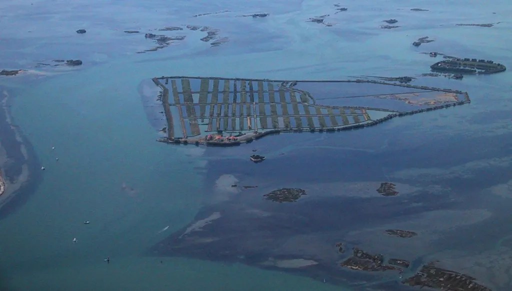
Isola Ravaiarina, Grado, Province of Gorizia
West of Isla Gorgo and Grado, eastern Marano Lagoon, Northern Italy, Italy
Isola Ravaiarina is a property with untapped tourist potential. The property has two defining features – a once-operational restaurant and a collection of purpose-built fish farm lagoons. A potential investor could once again harness the surrounding lagoon’s natural bounty for use in Isola Ravaiarina’s restaurant. An injection of capital is arguably the spark needed to bring the return of paying customers. Ravaiarina benefits from a fully functioning harbour, making transport to and from the mainland viable – the port at Grado is approximately one kilometre away by boat. The property’s unique features and pre-established facilities make it one of the more intriguing private islands for sale on the Italian market.
142 AcresFreehold
Listed 76 days ago

€1,250,000EUR
Ardoileán, High Island, County Galway
West coast of Barnanrusheen, south of Inishbofin, North Atlantic Ocean, Ireland
Ardoilean Island is a unique investment opportunity. The property, also known as High Island, is an expanse steeped in history, with archaeological artefacts inundating the ~79-acre plot. Foremost, church remnants on the island correlate with early Iron Age settlements. There is also the foundation of a monastery on Ardoilean’s southwestern edge that dates back to the seventh century. Other examples of historical relics are the remains of an old water mill, a granite globe, and a long-disused copper mine shaft. Beyond its historical reputation, Ardoilean endures as an island of immense natural value – serving as a haven for a vast array of birdlife. Fulmars, petrels, shearwaters, gulls, and oyster catchers live on the island. Barnacle geese also visit during the winter. There is a more modern building near Ardoilean’s southern landing area. A septic tank also suggests future building potential, though any construction would be subject to the necessary planning constraints. Due to its historical value, the resident monastery is not part of the sale. Regardless, the opportunity to own the surrounding island – one of such historical significance – is nothing short of rare.
79 AcresFreehold
Listed 76 days ago